Kettlewell in the Yorkshire Dales Kettlewell in the Yorkshire Dales Home Home History History Kettlewell Church Kettlewell Church Scarecrow Festival Scarecrow Festival
 
 
  Guest Accomm.   Self-Catering Accomm.   Businesses   Walks   Location   Gallery     Touring & Travel  


  Dowber Gill and Hag Dike
 
  Distance : 4 miles
 
 
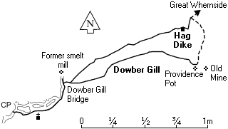
From "The Kings Head" take the lane up to the top of the village onto a dirt track. At the small bridge turn right then left over a stile keeping the beck on the right hand side. Follow the path past 5 Sisters Waterfalls on to Providence Pot (up on the right is Providence lead mine). Take the left fork for 200 yrds and then climb up the side of the shale on your left to the top.

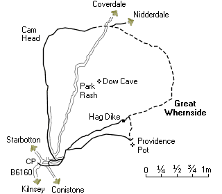
From there walk across to Hag Dyke (a scouts outward bound center) through the sheep pens and turn left down the path across pastures of short grass. There are superb views of Kettlewell in front of you and back to the village.
  Dowber Gill and Hag Dike

 
  Great Whernside
 
  Distance : 7.7 miles
 
 
Great Whernside


It is recommended that you only do
this walk if the weather is clear
 
From the top of the village follow the dirt track, at the small bridge turn right then left over a stile up the path in front of you across the pastures to "Hag Dyke". From there follow the sign to the top of Great Whernside (from the village maypole to the top of Great Whernside is a climb of 485 meters).

At the trig point turn left following the top ridge until you see a path on your left down to the Coverdale Road. Go across the road and follow the path down to a gate (on your left are earthworkings from the iron age built by the Brigantes to keep the Romans out of Coverdale).

Follow the path until you see a sign post and turn left down the track through the gates and across the top pastures and on to a walled road. Here you are following in the foot steps of Monks and travellers who walked this way centuries before. Half-way down is where Keith Melling painted his well-known picture of Kettlewell and now down to the village.


  Kettlewell - Arncliffe - Hawkswick
 
  Distance : 6.2 miles
 
 
From the village car park turn right across the bridge up into right hand corner. Through the gate take the path on your left hand side up though The Slit, looking back you get a birds eye view of Kettlewell. Follow the path across the hill up and up over Old Cote Little Moor and to a steep rocky descent into Arncliffe.

It’s a pretty village with one pub - "The Falcon.". Arncliffe is where Charles Kingsley wrote "The Water Babies". Pick up the path going down by the River Skirfare and along to Hawkswick. On entering the village the house on your right is named The Ballroom and was the Lyceum of Littondale.

In the village turn left up the path keeping the wall on your right up to Knipe Scar. Fork left up to the cairn and along to the woods as you go through the sheep folds. On your right down the hill side is a conifer tree - this was the garden of a railway carriage used as a holiday home which was removed by the Yorkshire Dales National Park Authority in the 1950s. And now on down over the top of the stone quarry to Kettlewell.
  Kettlewell - Arncliffe - Hawkswick


Facts     Kettlewell had a charter to hold a market in 1320 on Thursdays to sell sheep


a daelnet production
Webcraft by  q u a n t u m   d o t   k n o w l e d g e
Copyright © 2006 quantum dot knowledge